|
The highlands are our last longer stops in Iceland. We decided to visit two famous locations, which are accessible in mid-june by the highland bus: Þórsmörk and Landmannalaugar. Þórsmörk Þórsmörk is a nature reserve in the southern icelandic highlands, located between the glaciers Eyjafjallajökull, Mýrdalsjökull and Tindfjallajökull. The area is mainly a valley and a mountain range between the rivers Krossá, Þröngá, and Markarfljót. The spectacular landscapes with glaciers, woods and canyons make Þórsmörk a popular hiking destination. Landmannalaugar Landmannalaugar is a very unique area, both geologically and aesthetically. It is nested beside the black Laugahraun lava field, originally formed in an eruption in 1477. Landmannalaugar itself is made up of rhyolite mountains, a rock type that creates a large spectrum of glossy colours: shades of red, pink, green, blue, black, golden and yellow. Currently, it looks particularly beautiful as there are still many white snowfields in between.
0 Comments
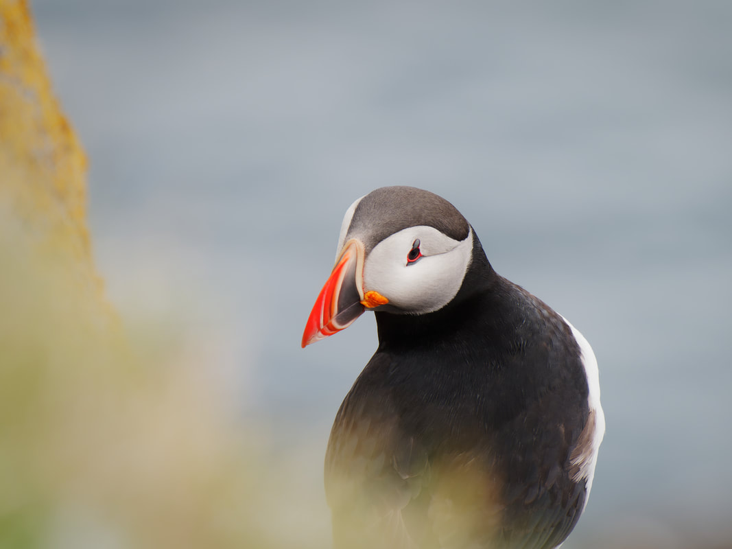
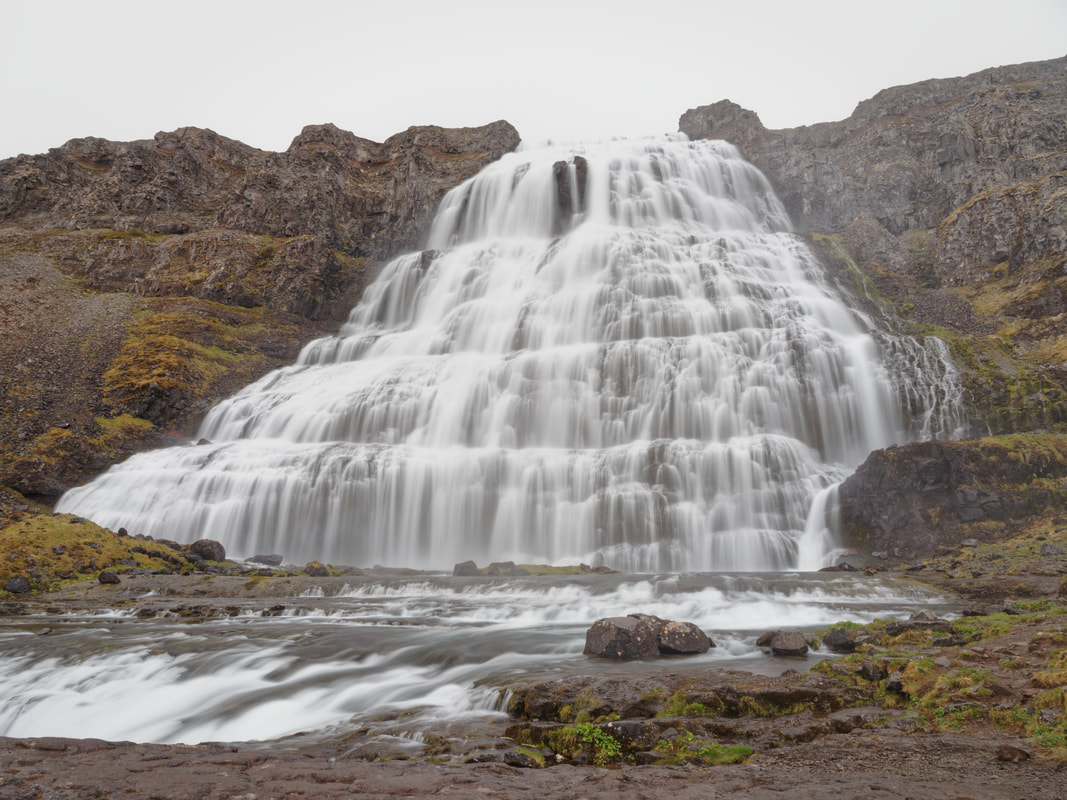
After crossing the Breiðafjörður by ferry, we reached the icelandic westfjords. They are one of the country's most spectacular region and very different from other parts that we have seen before. We decided to visit three locations in the southwestern part: Látrabjarg, Rauðasandur and the Dynjandi waterfall. Látrabjarg The Látrabjarg cliff is the westernmost point of Iceland and Europe. Furthermore, it is Europe’s largest bird cliff stretching 14 km and reaching a height of 441 m. The variety and sheer number of birds that can be seen in Látrabjarg are unique. At least one million of puffins nest here, often very close to the top of the cliff. Rauðasandur Rauðasandur is a long beach located near Látrabjarg. This beach is famous for its red and golden colors which are rather rare compared to the black sand beaches typical in Iceland. During summer, the beach looks somewhat tropical. Special shells are responsible for the red color, and since the Westfjords are no longer volcanically active, there is no constant source of ashy sands such as at the black sand beach near Vik at the south coast of Iceland. Dynjandi Dynjandi waterfall is located in the heart of the Westfjords. It is the biggest waterfall in this region, nearly 100 m high and 60 m wide at the bottom. Directly below Dynjandi are 6 other waterfalls which are also very beautiful. After some days in Reykjavik with very rainy weather and therefore not many opportunities for hiking or photographing, we traveled towards the westfjords. On our journey, we stopped in Stykkishólmur and on Flatey island in Breiðafjörður. Stykkishólmur Stykkishólmur is a small town in the northern part of the Snæfellsnes peninsula. It is a center of services and commerce for the area and has a naturally well sheltered harbour. Most of the people make their living from fishing and tourism. A ferry goes over a fjord called Breiðafjörður to the Westfjords and crosses the small island Flatey on its way. Flatey island Flatey is an island located in Breiðafjörður in the northwestern part of Iceland. It is about two kilometers long, one kilometer wide and very flat (hence its name, meaning "flat island" in Icelandic). In the whole area of Breiðafjörður are about 3000 islands. The region is spectacular and consists of shallow waters, small fjords and bays as well as intertidal areas. The island has a seasonal habitation because most of the houses are only inhabited during summer. Akureyri and Hrisey island are our last longer stops in northern Iceland. After these destinations, we travel back to Reykjavik and stay there for a few days and some daily tours. And very important: The icelandic spring has definitely begun! Akureyri Akureyri is the centre of trade and services in northern Iceland. With a population of about 19.000, it is the second largest urban area outside the capital area of Reykjavík. The town is situated in one of the longest fjords in the country and is surrounded by mountains reaching up to 1500 m. Akureyri is a popular tourist destination and a good location for hiking or whale watching. Hrisey island Hrisey is a small island, also known as Eyjafjörður's pearl of nature. It is renowned for its abundant birdlife. The island lies out in the middle of the fjord and can be reached by a ferry. There are a small fishing village and some hiking trails.  Siglufjörður Siglufjörður is Iceland’s northernmost town on the mainland, located in a fjord and surrounded by steep mountains. It is a historic fishing town famous for its fishing industry during the 20th century. After 1903, it became one of the largest towns in Iceland and the capital of herring fishing in the northern Atlantic. In 1968, the whole industry collapsed by a sudden decrease in herring stock. Today, a very recommended museum about this herring era can be visited. Dalvik Dalvík became a small village little more than a century ago. Before that, the area consisted of scattered farmsteads and few buildings dedicated to the fishing industry. Nowadays the area is suitable for a lot of hikes. Therefore we rented a small cottage for a few days. Grimsey Island Grímsey is a small island on the Arctic Circle, just 40 km off the north coast of Iceland. It is Iceland's most northern point, home of less than one hundred people and thousands of seabirds. The island stands alone far out on the horizon, a blue cliff, surrounded by the wide Arctic Ocean. It is about 5 square kilometers in area. We slept in a very nice guesthouse located directly at the small airport outside of the village, only surrounded by thousands of seabirds. |