|
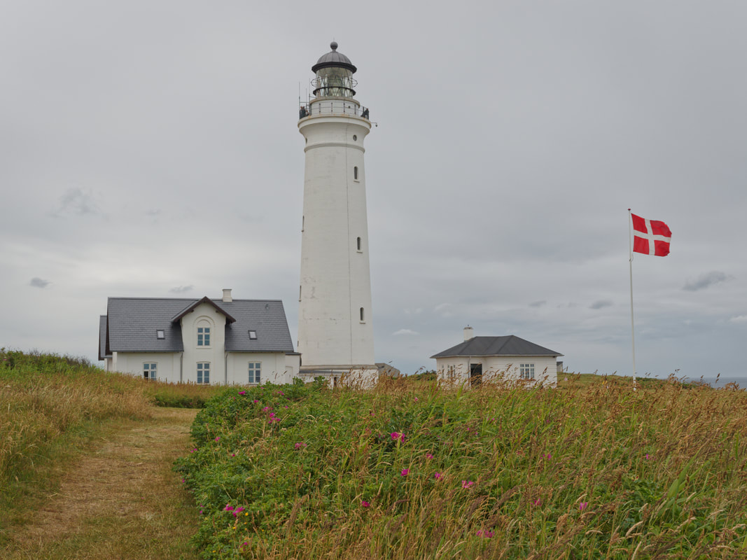
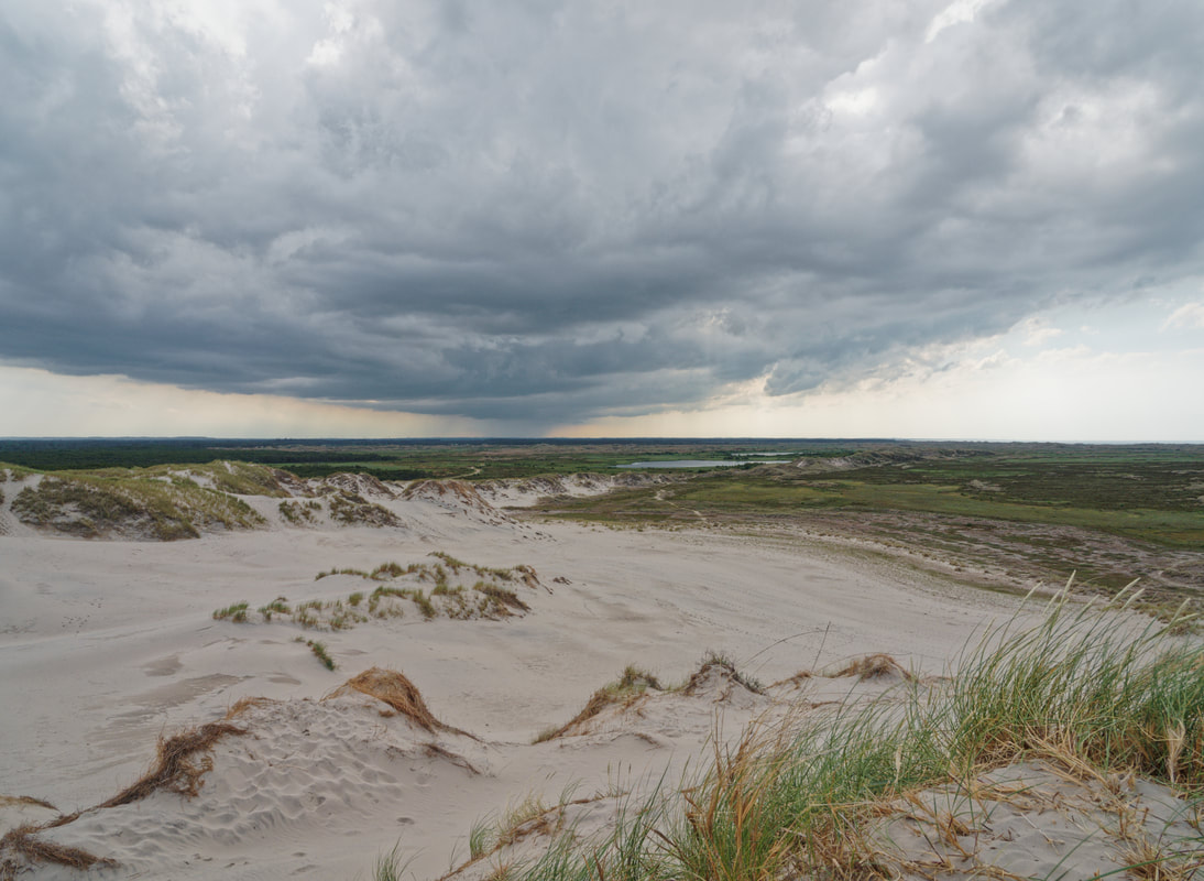
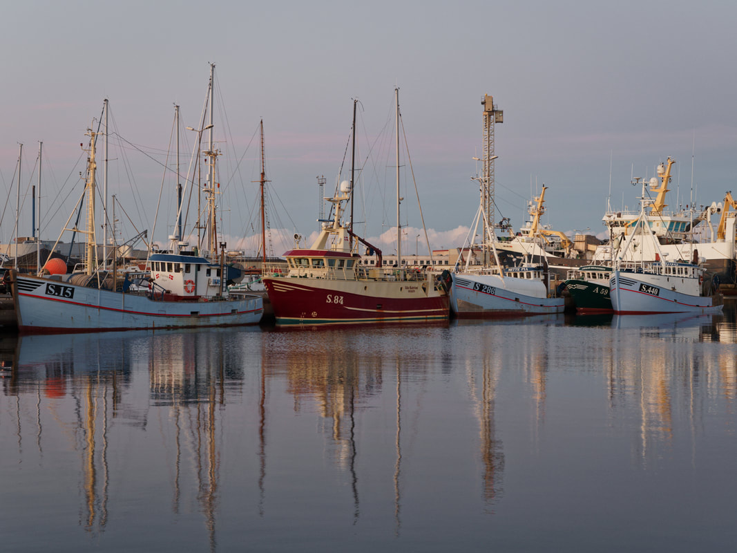
After our arrival in Hirtshals (DK) by ferry, we hiked the Nordsøstien (North Sea Trail) from Hirtshals to Skagen. The Nordsøstien is a very beautiful and well-marked hiking trail that leads along beaches, through forests and wide dune landscapes. Skagen is our last destination on our first trip to the north. After Skagen, we will travel back to Switzerland for the COVID-19 vaccination. In August 2021, we plan to continue our journey in northern europe, so stay tuned for further blog updates in a bit more than a month. Hirtshals Hirtshals is a town with a seaport at the coast of Skagerrak close to the top of the Jutland peninsula in northern Denmark. Fishing plays a major role in the town, as does tourism and the renting of summer houses in the well-known holiday area. There is a beautiful lighthouse next to some old military infrastructure from the second world war. Skagen Skagen is the northernmost place in Denmark and renowned for its amazing light, unique nature and white sandy beaches. It is situated near Grenen, where the Baltic sea meets the North sea. Other very beautiful places to visit around Skagen are the “Råbjerg Mile”, North Jutland's Sahara desert, and the sand-covered church called “Den Tilsandede Kirke”. We enjoyed our last days in Skagen very much and will hopefully come back again one day in the future.
1 Comment
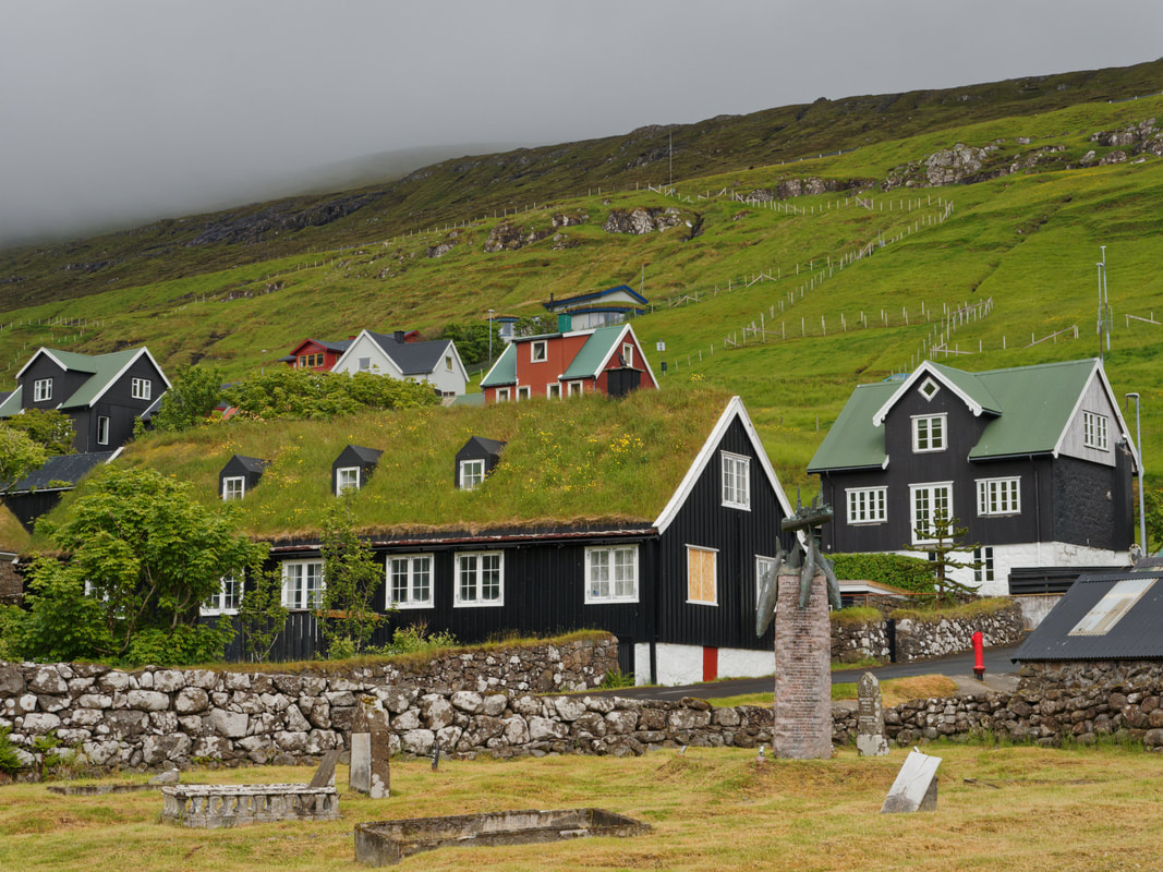
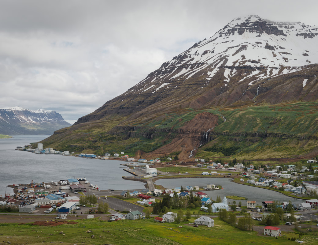
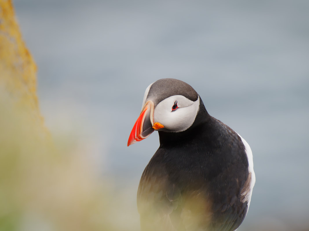
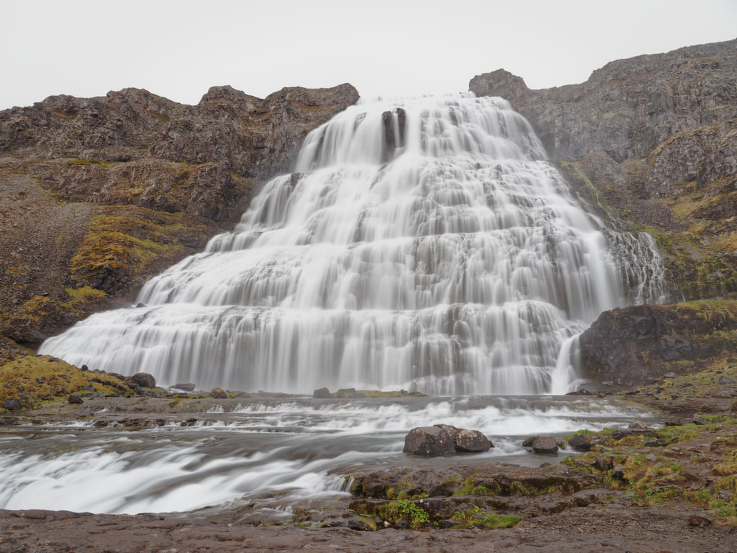
The Faroe Islands lie on our trip back to the european mainland. We have visited these islands already in 2017, and we have never forgotten the incredible beauty of this archipelago. Now we are really happy to see them again. The 18 small islands are characterised by steep cliffs, tall mountains and narrow fjords. After visiting the Faroe Islands we are travelling to Hirtshals/DK by ferry and then we will hike from Hirtshals to Skagen on the Nordsøstien (NorthSeaTrail). Streymoy (Tórshavn, Kvivik, Vestmanna) Streymoy is the largest and most populated island of the Faroes Islands. Tórshavn is the capital and largest city and lies in the southern part of Streymoy. Kvivik and Vestmanna are two villages that lie in the northern part of the island. They are absolutely worth visiting and offer various possibilities for hiking. Eysturoy (Gjógv) Eysturoy is the second-largest island. We visited the small village Gjógv, which is in our opinion one of the most beautiful villages that we’ve seen so far. Gjógv is named after the 200 metre long sea-filled gorge which is used as a natural harbour. Vágar (Sørvágur, Miðvágur) On Vágar is the largest lake of the country - Sørvágsvatn or Leitisvatn. The lake lies only about 30 meters above the ocean. The steep and significant elevation changes of the surrounding hills give the lake a very unique look. Vágar is also home to the islands’ only airport. Norðoyar (Klaksvik, Trøllanes, Árnafjørður, Trøllanes, Viðareiði) The six islands in the northeast are together referred to as Norðoyar, i.e. the Northern Isles. The area offers stunning views and beautiful hikes, but because of the foggy weather, we had to adjust our hiking plans. One of the most famous places is the Kallur lighthouse on Kalsoy Island. Mykines Mykines is the westernmost of the 18 main islands. The only settlement with a population of about 10 inhabitants is called Mykines as well. The island is famous for its rich birdlife as it is a significant breeding site for seabirds. Seyðisfjörður in east Iceland is our last stop in Iceland. After that we will travel to the Faroe Islands by ferry and stay there for another 10 days. Seyðisfjörður The small town Seyðisfjörður is located between Mt. Bjólfur (1085m) and Strandartindur (1010m). The center of the town is beautifully located around the lagoon and is well known for its original early 19th-century timber houses. Bye bye Iceland After little more than three months in Iceland, it is time for us to say goodbye to this very beautiful country in the northern atlantic. It was an excellent idea and a unique opportunity to travel to Iceland during this time, because under normal circumstances, the island would have been much more crowded. During the last weeks we noticed the steadily growing tourism, so for us it is the right moment to leave the island. We will never forget being almost alone in such famous places like Skógafoss or the Geysir hot spring area. The highlands are our last longer stops in Iceland. We decided to visit two famous locations, which are accessible in mid-june by the highland bus: Þórsmörk and Landmannalaugar. Þórsmörk Þórsmörk is a nature reserve in the southern icelandic highlands, located between the glaciers Eyjafjallajökull, Mýrdalsjökull and Tindfjallajökull. The area is mainly a valley and a mountain range between the rivers Krossá, Þröngá, and Markarfljót. The spectacular landscapes with glaciers, woods and canyons make Þórsmörk a popular hiking destination. Landmannalaugar Landmannalaugar is a very unique area, both geologically and aesthetically. It is nested beside the black Laugahraun lava field, originally formed in an eruption in 1477. Landmannalaugar itself is made up of rhyolite mountains, a rock type that creates a large spectrum of glossy colours: shades of red, pink, green, blue, black, golden and yellow. Currently, it looks particularly beautiful as there are still many white snowfields in between. After crossing the Breiðafjörður by ferry, we reached the icelandic westfjords. They are one of the country's most spectacular region and very different from other parts that we have seen before. We decided to visit three locations in the southwestern part: Látrabjarg, Rauðasandur and the Dynjandi waterfall. Látrabjarg The Látrabjarg cliff is the westernmost point of Iceland and Europe. Furthermore, it is Europe’s largest bird cliff stretching 14 km and reaching a height of 441 m. The variety and sheer number of birds that can be seen in Látrabjarg are unique. At least one million of puffins nest here, often very close to the top of the cliff. Rauðasandur Rauðasandur is a long beach located near Látrabjarg. This beach is famous for its red and golden colors which are rather rare compared to the black sand beaches typical in Iceland. During summer, the beach looks somewhat tropical. Special shells are responsible for the red color, and since the Westfjords are no longer volcanically active, there is no constant source of ashy sands such as at the black sand beach near Vik at the south coast of Iceland. Dynjandi Dynjandi waterfall is located in the heart of the Westfjords. It is the biggest waterfall in this region, nearly 100 m high and 60 m wide at the bottom. Directly below Dynjandi are 6 other waterfalls which are also very beautiful. After some days in Reykjavik with very rainy weather and therefore not many opportunities for hiking or photographing, we traveled towards the westfjords. On our journey, we stopped in Stykkishólmur and on Flatey island in Breiðafjörður. Stykkishólmur Stykkishólmur is a small town in the northern part of the Snæfellsnes peninsula. It is a center of services and commerce for the area and has a naturally well sheltered harbour. Most of the people make their living from fishing and tourism. A ferry goes over a fjord called Breiðafjörður to the Westfjords and crosses the small island Flatey on its way. Flatey island Flatey is an island located in Breiðafjörður in the northwestern part of Iceland. It is about two kilometers long, one kilometer wide and very flat (hence its name, meaning "flat island" in Icelandic). In the whole area of Breiðafjörður are about 3000 islands. The region is spectacular and consists of shallow waters, small fjords and bays as well as intertidal areas. The island has a seasonal habitation because most of the houses are only inhabited during summer. Akureyri and Hrisey island are our last longer stops in northern Iceland. After these destinations, we travel back to Reykjavik and stay there for a few days and some daily tours. And very important: The icelandic spring has definitely begun! Akureyri Akureyri is the centre of trade and services in northern Iceland. With a population of about 19.000, it is the second largest urban area outside the capital area of Reykjavík. The town is situated in one of the longest fjords in the country and is surrounded by mountains reaching up to 1500 m. Akureyri is a popular tourist destination and a good location for hiking or whale watching. Hrisey island Hrisey is a small island, also known as Eyjafjörður's pearl of nature. It is renowned for its abundant birdlife. The island lies out in the middle of the fjord and can be reached by a ferry. There are a small fishing village and some hiking trails.  Siglufjörður Siglufjörður is Iceland’s northernmost town on the mainland, located in a fjord and surrounded by steep mountains. It is a historic fishing town famous for its fishing industry during the 20th century. After 1903, it became one of the largest towns in Iceland and the capital of herring fishing in the northern Atlantic. In 1968, the whole industry collapsed by a sudden decrease in herring stock. Today, a very recommended museum about this herring era can be visited. Dalvik Dalvík became a small village little more than a century ago. Before that, the area consisted of scattered farmsteads and few buildings dedicated to the fishing industry. Nowadays the area is suitable for a lot of hikes. Therefore we rented a small cottage for a few days. Grimsey Island Grímsey is a small island on the Arctic Circle, just 40 km off the north coast of Iceland. It is Iceland's most northern point, home of less than one hundred people and thousands of seabirds. The island stands alone far out on the horizon, a blue cliff, surrounded by the wide Arctic Ocean. It is about 5 square kilometers in area. We slept in a very nice guesthouse located directly at the small airport outside of the village, only surrounded by thousands of seabirds. After our stops in east Iceland, we are travelling west in the northern part of Iceland. Mývatn Lake Mývatn is a lake in north Iceland. It was formed by a large basaltic lava fissure eruption about 2300 years ago. The volcanic landscape is dominated by pseudo craters. The idyllic blue lakes, hot pools, sandy mountains and volcanic craters make up an incredible setting and build various fascinating sceneries. Goðafoss Goðafoss is a waterfall in the river Skjálfandafljót, the fourth largest river in Iceland. It is one of the most spectacular waterfalls in the country, falling over a width of 30 metres from a height of 12 metres. Húsavík The town of Húsavík is located on the eastern shore of Shaky Bay and is well-known as the “Whale Capital of Iceland”. We also went out for a whale watching tour and saw a humpback whale. Húsavík is also the place where the first house of Iceland was built, back in the year 860 by the swedish viking Garðar Svavarsson. We are travelling further along the south coast direction east to our next longer stop in Höfn. Skaftafell Skaftafell is a nature reserve and part of the Vatnajökull National Park in the south east of Iceland. Its location is unique as it lies between sandy beaches at the coast and inland glaciers. The region is well known for its rich flora and there are a lot of natural attractions, from cascading waterfalls to glacier lagoons and from geological formations to black sand deserts. Jökulsárlón Jökulsárlón and the nearby Diamond Beach are one of Iceland's most fantastic natural attractions. They are famous for the free-floating icebergs and the ice blocks laying on the black beach resembling diamonds glittering in the sun. Typically, thousands of people are drawn to Jökulsárlón all year round. However, COVID-19 has drastically reduced the number of visitors, and during our stay there were only a few other tourists. Höfn Höfn i Hornafjörður is a blooming village close to the biggest glacier in Europe, Vatnajökull. Höfn's growth during the 20th century from a small village to today's town was a result of the development of a diverse fishing industry. Only a few kilometers away from Höfn lays the Stokksnes peninsula and the famous Vestrahorn mountain, a popular spot especially for photographers. |